
Exercise: Data preparation (Importing PDF tables into QGIS) #
Characteristics of the exercise #
Instructions for the Trainers #
Attention
This exercise makes use of the tabula.technology tool, an open source application which let’s you easily extract tables from a PDF-file. Tabula requires you to have Java installed on your device.
Trainers Corner
Prepare the training
Take the time to familiarise yourself with the exercise and the provided material.
Prepare a white-board. It can be either a physical whiteboard, a flip-chart, or a digital whiteboard (e.g. Miro board) where the participants can add their findings and questions.
Before starting the exercise, make sure everybody has installed QGIS and has downloaded and unzipped the data folder.
Check out How to do trainings? for some general tips on facilitating trainings.
Conduct the training
Introduction:
Introduce the idea and aim of the exercise.
Provide the download link and make sure everybody has unzipped the folder before beginning the tasks.
Follow-along:
Show and explain each step yourself at least twice and slow enough so everybody can see what you are doing, and follow along in their own QGIS-project.
Make sure that everybody is following along and doing the steps themselves by periodically asking if anybody needs help or if everybody is still following.
Be open and patient to every question or problem that might come up. Your participants are essentially multitasking by paying attention to your instructions and orienting themselves in their own QGIS-project.
Wrap up:
Leave time for any issues or questions concerning the tasks at the end of the exercise.
Leave some time for open questions.
Exercise #
Available Data #
Download the datasets here and unzip them.
Dataset |
Source |
Description |
|---|---|---|
Administrative boundaries for pakistan |
The administrative boundaries (adm0-adm3) for pakistan can be accessed via the humanitarian data exchange. For this exercise, we are interested in the districts (adm2) |
|
Percent distribution of households by material used for walls |
Table 7.7 in the Pakistan Social and living Standards Measurement Survey (2019-20) shows the materials used for walls per household in percents. |
Task 1: Get the data from the PDF file into a CSV file #
In your web-browser, go to Tabula.technology and download the application.
Tabula
Tabula is an open source application that let’s you extract data tables from PDF-files as .csv-files. The .csv-files can be imported into excel, QGIS, or other data manipulation programs.
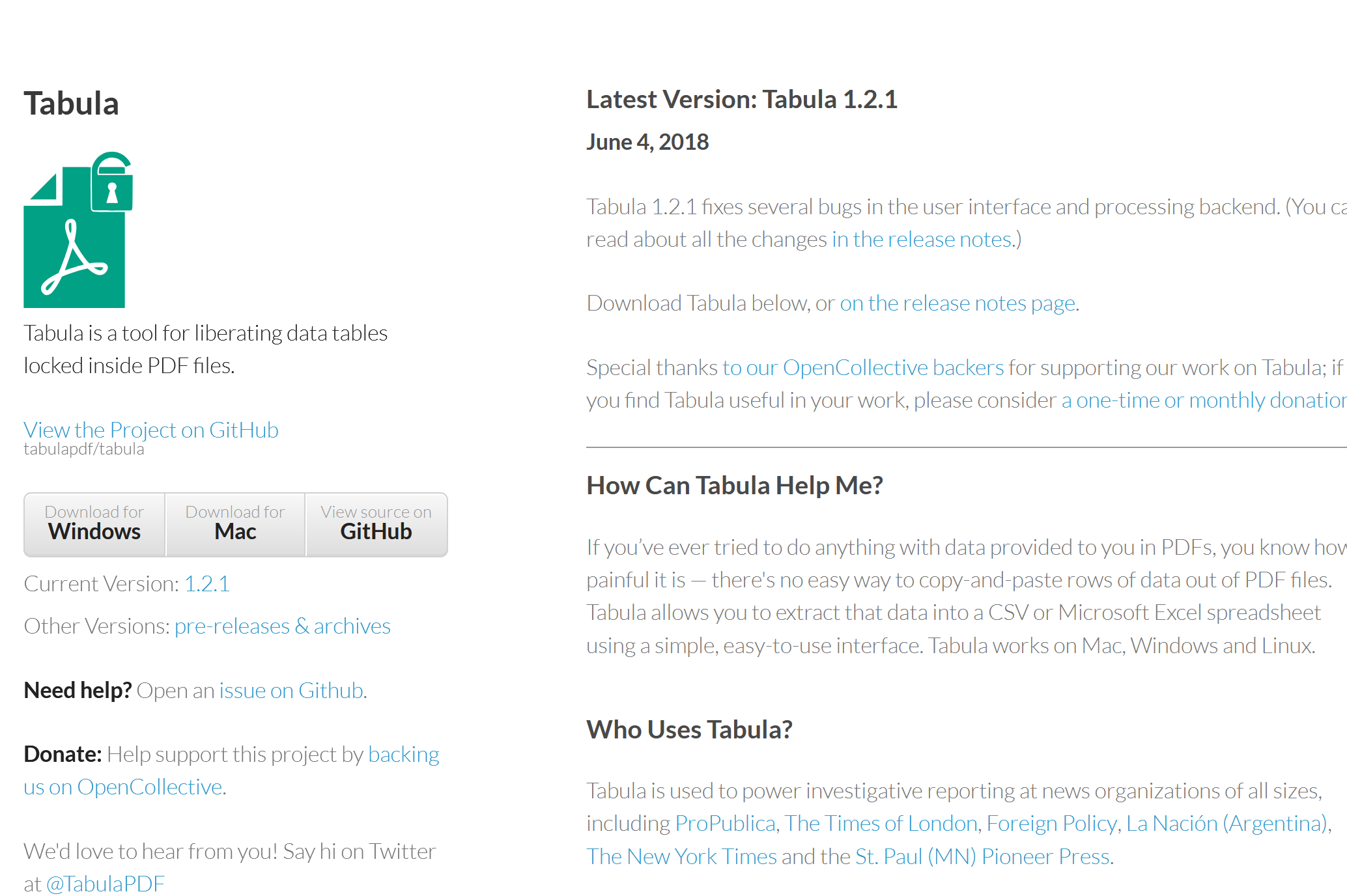
The Tabula.technology website with the download links to the left.#
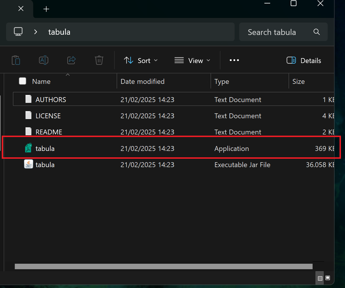
Unzip the downloaded file into a location of your choosing (e.g., Programs, Desktop, …).
Open the folder where you unzipped the file and open the “Tabula” application.
A new browser window will open with this address: http://localhost:8080. This is the application. If the browser does not open automatically, you can open the browser and enter this go to this address manually.
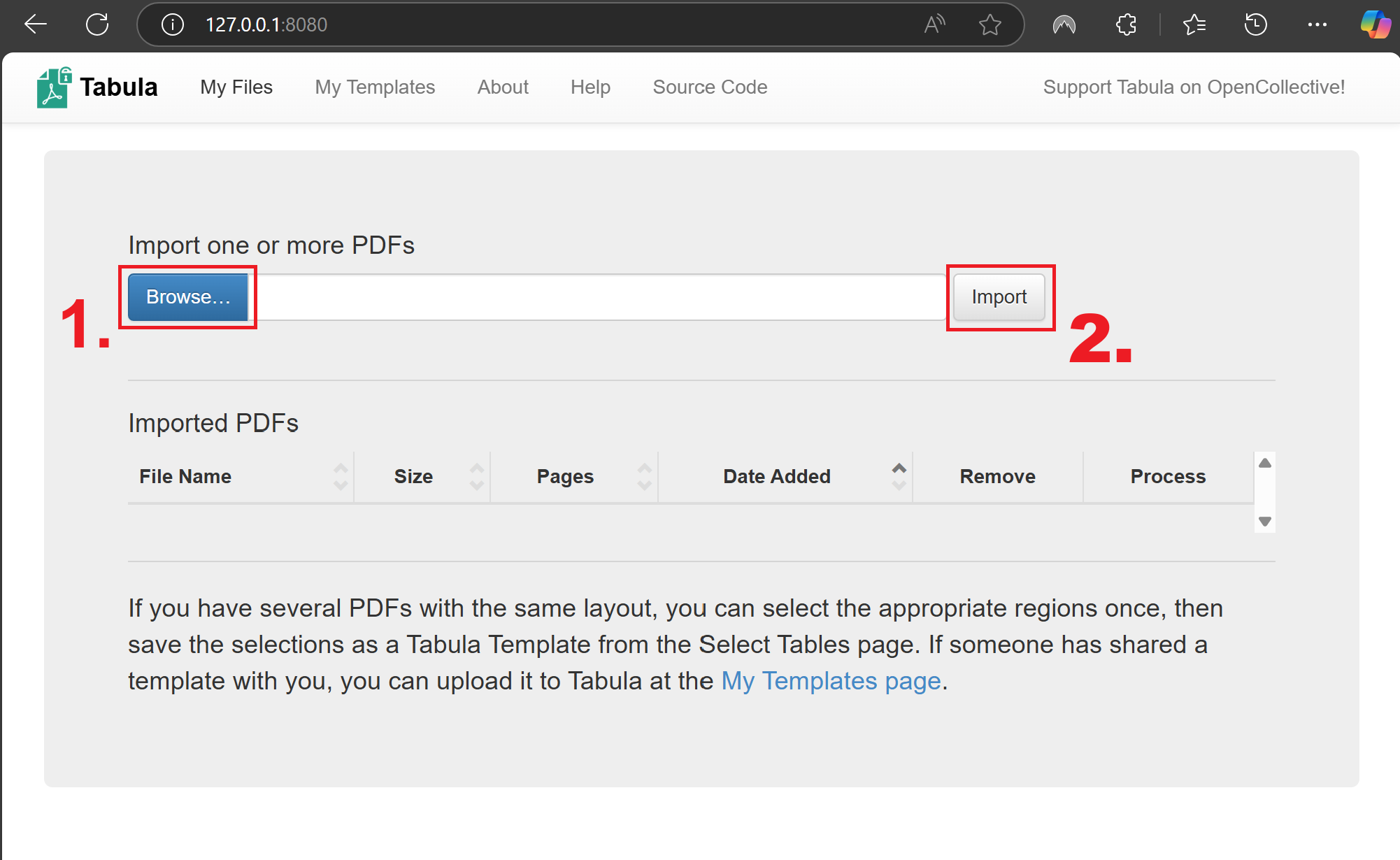
Now let’s import the PDF file with the wall types into tabula:
Click on
Browseand navigate to the exercise data folder:...\data\inputand select the PDF “pakistan_wall_type7.7”. ClickOpen.Click
Importand wait for the PDF to load. Once loaded, it will open automatically.
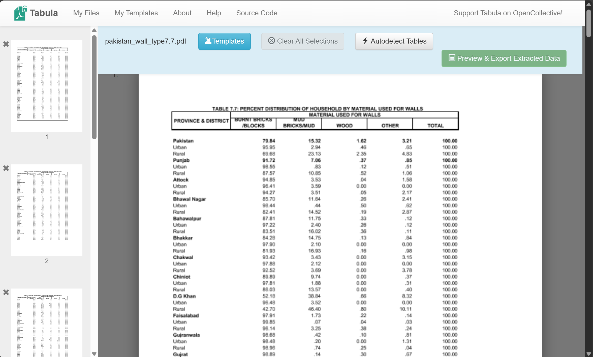
Here we will select the portion of the PDF that contains the data table. Tabula expects a table with one row of headers at the top for each column, followed by the rows with the data. By dragging a rectangle on the PDF, we can create a selection where tabula should look for the data table. Drag a rectangle and adjust the boarders so the table fits as precisely as possible into selection. Make sure to only capture the relevant information. Since the headers in this table has an unconventional formatting, it should be left out so the resulting csv table is easier to adjust. We will add the headers manually once extracted.
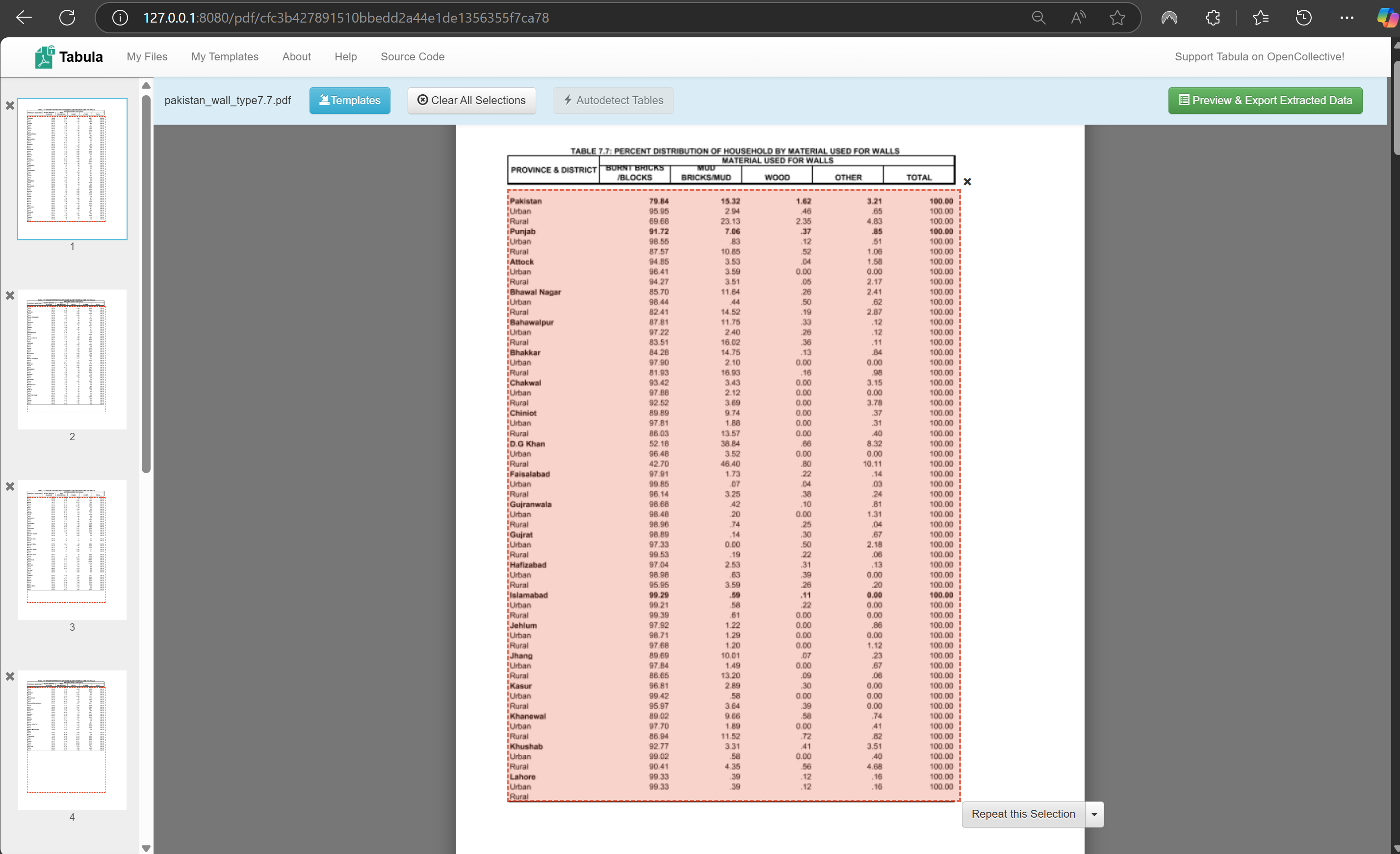
Once you are satisfied with the selection, you can click on
Repeat this Selectionto duplicate the selection on the next pages.Take a look on the following pages and make sure the table is still fully contained by the selection.
Click on
Preview & Export Extracted Dataon the top right of the window.A new window will appear where the data will show up. At first, nothing will be visible. First, click on
Streamon the left.
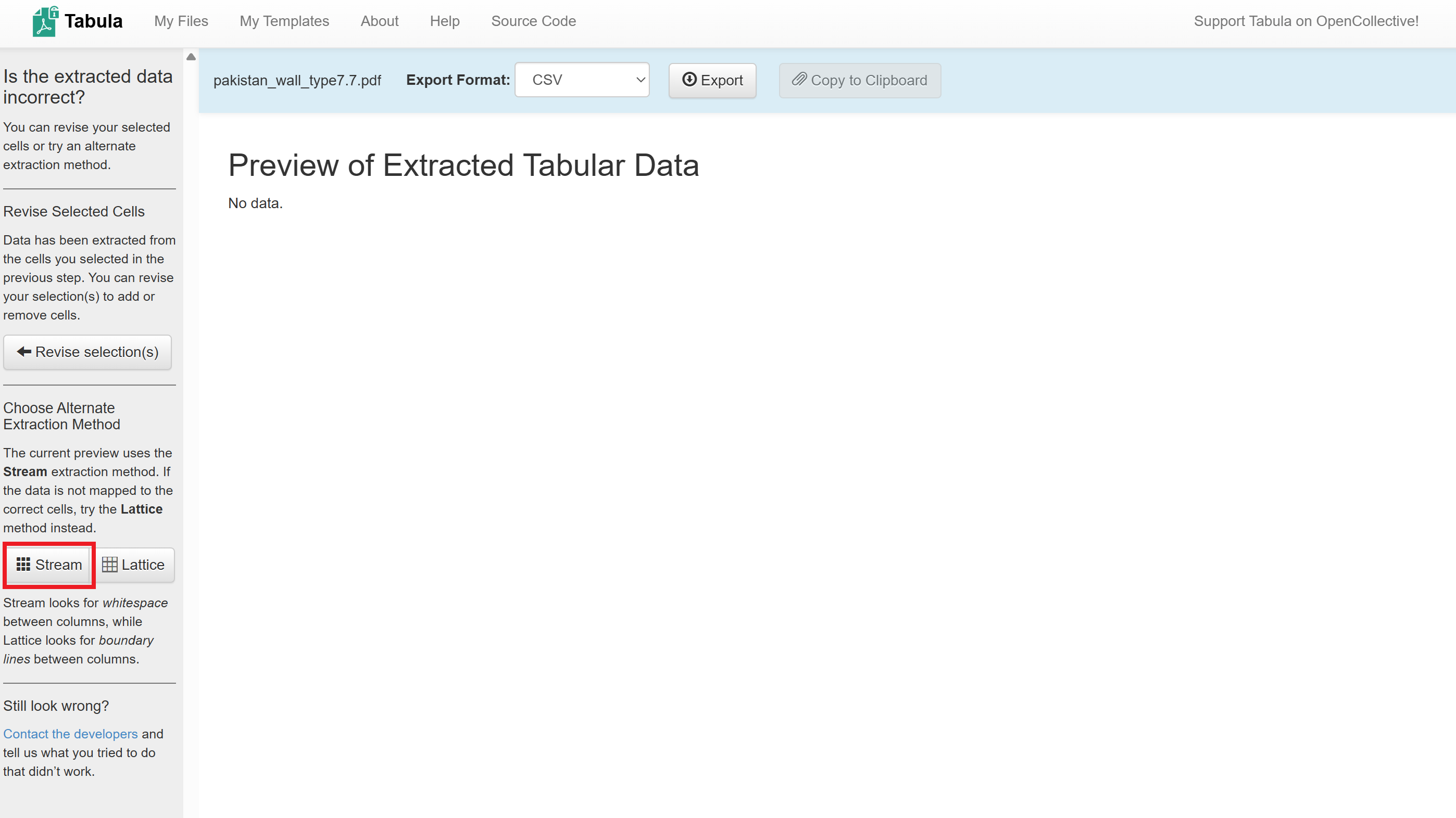
The data from the PDF table will appear in the main window. Review the table.
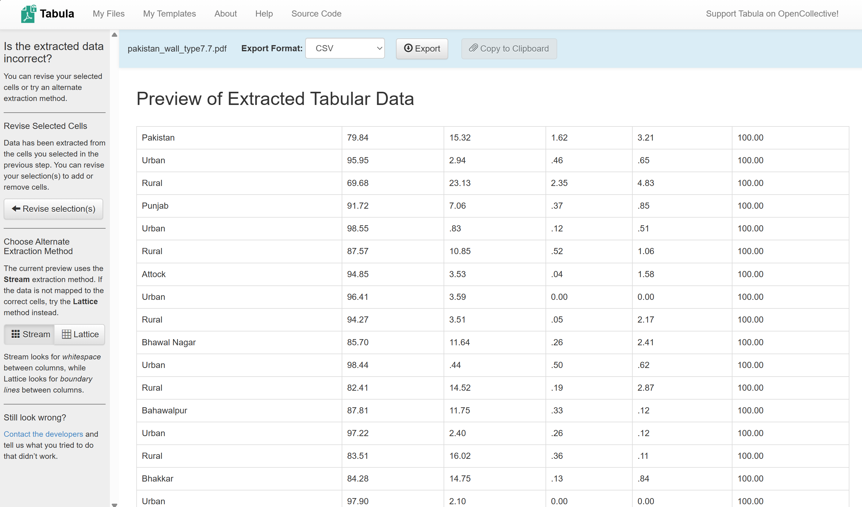
Click on
Export, this will save the.csvinto your downloads folder.Move the file to the
/data/interim/-folder.
Congratulations, the data from the PDF has been extracted into a CSV file!
Task 2: Clean the CSV file #
Attention
For this task, use the prepared file tabula-pakistan_wall_type7.7_training.csv from the exercise data folder (data/input/). It’s the Tabula output where most of the problems have already been fixed, so you only have to fix a few rows.
If you extracted the table yourself in Task 1, your file has more problems. See the dropdown “If you extracted the CSV yourself” at the end of this task.
Open
tabula-pakistan_wall_type7.7_training.csvin a spreadsheet editor such as Microsoft Excel or LibreOffice Calc.
Note
If Excel shows all values in column A, select column A and go to Data → Text to Columns (in the web version of Excel: Data → Split Text to Columns). Leave the settings as they are and click OK.
Go through the table and look for these problems:
What went wrong in the extraction?
Problem |
Rows affected |
Example |
How to fix it |
What happens in QGIS if you don’t fix it |
|---|---|---|---|---|
Column headers split over three rows |
The first three rows |
|
Make one header row: |
QGIS takes the first row as column names, so the columns get the wrong names. The other header rows become data, so all number columns are read as text. |
Two numbers in one cell |
Faisalabad, Lahore |
|
Move the first number into Mud and keep the second in Wood. |
QGIS reads the whole Wood column as text instead of numbers. You can’t use it for a map. |
Name and number in one cell |
Nushki, Sohbatpur |
|
Move Mud, Wood and Other one column to the right, then move the number from the name into Burnt Bricks/Blocks. |
The district name is |
A name split over two rows |
Tando Muhammad Khan (Sindh) |
|
Write the full name |
|
Rows that are not districts |
|
|
Delete these rows. We only want one row per district. Read the note first: it lists the districts that are missing from the survey. |
Extra rows that don’t belong to any district. |
Values such as .22 are fine: they mean 0.22.
Fix the rows with these problems. To check your work, add a column that adds up Burnt Bricks/Blocks, Mud Bricks/Mud, Wood and Other, e.g.
=SUM(B2:E2). For every district, the result should be about 100. If it isn’t, the values in that row are still in the wrong columns. Delete the check column when you’re done.Save the file as CSV (
File→Save As, file typeCSV (Comma delimited)) in the folderdata/interim/under the namepakistan_wall_type_clean.csv. If Excel asks whether to keep the format, choose to keep CSV.
Great! Now we are ready to import the CSV-file into QGIS!
If you extracted the CSV yourself
Your own Tabula output has the same problems as the prepared file, but in more rows, and some more:
No column headers: we didn’t select the headers in Tabula. Insert a new first row and enter the headings:
Province & District
Burnt Bricks/Blocks
Mud Bricks/Mud
Wood
Other
Total
Urban and Rural rows: below every district, there is one row for urban and one for rural areas. We only need the district totals. Select the table, go to
Home→Format as Table, then click the arrow next to “Province & District” and useText Filters→Begins With...to show all rows that begin withUrban, and then all that begin withRural. Some of these rows have a number attached to the word (e.g.Urban 55.06), so “Equals” would miss them. Select the filtered rows, delete them and remove the filter.More district names that don’t match the boundaries, e.g.
Layyah(in the boundaries:Leiah) orKarachi East(East Karachi). You will find them in Task 4.
Your file may also look slightly different depending on how you drew the selection in Tabula.
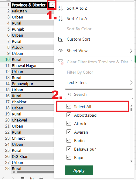
Filtering the rows in Excel.#
Task 3: Import the data into QGIS #
Open QGIS, create a new project and save it in the exercise folder.
Import the cleaned CSV file
data/interim/pakistan_wall_type_clean.csv. In the Data Source Manager:Under
Geometry Definition, selectNo geometry (attribute only table). Our CSV has no coordinates, only district names.Under
Record and Fields Options, make sureDetect field typesis checked.Click
Add.
Import the administrative boundaries
pak_admbnda_adm2_wfp_20220909.shpfrom the folderdata/input/pak_adm_wfp_20220909_shp/.Check that QGIS has read the numbers as numbers: Right-click on the CSV layer →
Properties→Fields. Burnt Bricks/Blocks, Mud Bricks/Mud, Wood and Other should have the typedouble(a decimal number). If one of them istextorstring, a cell in that column still has a problem. Fix it in the spreadsheet, save the CSV, remove the layer and import it again.
Task 4: Join the data to the districts #
Open the processing toolbox, search for “Join attributes by field value” and double-click on it.
Set the following parameters:
Input layer:
pakistan_wall_type_clean(the CSV)Table field:
Province & DistrictInput layer 2:
pak_admbnda_adm2_wfp_20220909Table field 2:
ADM2_ENLayer 2 fields to copy:
ADM2_PCODEUnjoinable features from first layer: click on the arrow next to the field and select
Create Temporary Layer.
Click
Run. In theLogtab, you can see how many rows were joined and how many weren’t.Open the attribute table of the new layer
Unjoinable features from first layer. These are the districts whose name in the CSV doesn’t exist in the boundary layer. You should find four:D.G KhanandKarachi centralChitralandKohistan
Open the attribute table of
pak_admbnda_adm2_wfp_20220909and click on the column headerADM2_ENto sort the names. Look for the correct names:D.G KhanisDera Ghazi Khan, andKarachi centralisCentral Karachi.ChitralandKohistandon’t exist anymore: in the boundary layer, they have been split into smaller districts (Chitral Lower,Chitral Upper,Kohistan Lower,Kohistan Upper,Kolai Palas Kohistan). The boundaries changed after the survey, so we can’t fix this by changing the name. We leave these two as they are.
QGIS can’t edit CSV files directly, so we first save the table in an editable format: Right-click on the CSV layer →
Export→Save Features As.... SetFormattoGeoPackageand save it asdata/interim/pakistan_wall_type_clean.gpkg. ClickOK. The new layer is added to your project.Select the new layer, click on the pencil icon (
Toggle Editing) and open its attribute table. Double-click onD.G Khanand change it toDera Ghazi Khan. ChangeKarachi centraltoCentral Karachi. Click onSave Editsand turn off the editing mode.Now join the data to the district polygons. Open “Join attributes by field value” again and set:
Input layer:
pak_admbnda_adm2_wfp_20220909Table field:
ADM2_ENInput layer 2:
pakistan_wall_type_clean(the GeoPackage layer)Table field 2:
Province & DistrictLayer 2 fields to copy:
Burnt Bricks/Blocks,Mud Bricks/Mud,Wood,OtherJoined layer: save it as
data/output/pakistan_wall_type_districts.gpkg
Click
Run.
Congratulations, we have now joined the information from the PDF file to the district polygons!
Note
The Log tab still shows quite a few polygons that weren’t joined. That’s expected: these districts have no data in the survey. They are
the districts in Azad Kashmir and Gilgit-Baltistan, which the survey doesn’t cover,
the five districts in the note at the end of the CSV,
Chitral and Kohistan, and the districts Chaman and Lehri, which were created after the survey.
Not every missing value is a mistake. But always check why something didn’t join.
Task 5: Visualisation of the Data #
Open the layer styling panel for the joined layer and select the Graduated symbolisation method.
Under
Value, selectBurnt Bricks/Blocks.Click on
Classify.
The resulting symbolisation could look something like this:
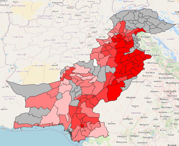
The darker the colour, the higher the percentage of households having burnt bricks or blocks as wall type. The grey areas are the districts where there is no data available.#